
fgibson
Member
Hey Guys,
I've been building a photo field airport and have learned a lot reading old posts. I have a decent looking panorama but...
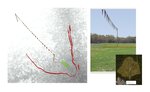
This airfield is surrounded by trees. The pano center point was the pilot position a few feet off to the side of the runway and in the middle of the runway lengthwise.
The scale of the photo just doesn’t match with RF. Especially on the South side of the runway. It's about 340 feet' from center of the runway to the tree line on each side. But on the south side, in order to place an object against the bottom of the tree line, I have to move that object (based on RF's scale) thousands of feet away from the pilot. The attached pilot spawn view shows a flag line on the south side that is 2,000 feet according to RF. On the North side, RF measures about 600 feet from pilot to tree line.
The safety fence visible in the south view is much closer to where the tree line should be based on RF's scale, about 400 feet from pilot position. If I place a buffer there, then when the plane hits the tree line it falls back to the middle of the runway. Looks pretty silly.
I don't understand why there is such a difference on the south side. I assume this is a photo issue but I wonder if there is a way to change the scale of RF to match the photo. The pano was shot on iPhone fully zoomed out (about = to a 30mm lens). I reshot with it zoomed in about a third of the way hoping to give the view of a 50mm lens but that didn’t help.
I've been building a photo field airport and have learned a lot reading old posts. I have a decent looking panorama but...
This airfield is surrounded by trees. The pano center point was the pilot position a few feet off to the side of the runway and in the middle of the runway lengthwise.
The scale of the photo just doesn’t match with RF. Especially on the South side of the runway. It's about 340 feet' from center of the runway to the tree line on each side. But on the south side, in order to place an object against the bottom of the tree line, I have to move that object (based on RF's scale) thousands of feet away from the pilot. The attached pilot spawn view shows a flag line on the south side that is 2,000 feet according to RF. On the North side, RF measures about 600 feet from pilot to tree line.
The safety fence visible in the south view is much closer to where the tree line should be based on RF's scale, about 400 feet from pilot position. If I place a buffer there, then when the plane hits the tree line it falls back to the middle of the runway. Looks pretty silly.
I don't understand why there is such a difference on the south side. I assume this is a photo issue but I wonder if there is a way to change the scale of RF to match the photo. The pano was shot on iPhone fully zoomed out (about = to a 30mm lens). I reshot with it zoomed in about a third of the way hoping to give the view of a 50mm lens but that didn’t help.
")