Terrain Modeling Experiments

mwilson914

Well-known member
To start this thread out, yes, this pertains to my secret project that keeps getting serious delays. I'm modeling the Snoqualmie Valley, or I want to anyhow. In the mean time, I'm experimenting.

I'm going to start this thread out with some screenshots and show you that it is possible to add terrain to Realflight...sort of.

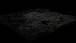
The complexities are extreme because the terrain needs to be collidable everywhere there is land. This means the landscape no matter the size needs to be under 8,000 polys. Ugh! It's entirely possible and I'll show you how later on. It's entirely possible to have your very own created terrain the size of Sierra Nevada in Realflight AND be high res if you want it to be. However, you'll have to create it as seperate objects which line up like a puzzle.

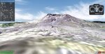
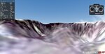
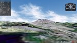
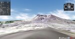
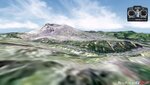
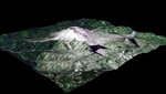
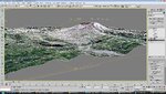
For now, these are screenshots of Mt. St. Helens. It's made by using the DISPLACE modifier in 3DS Max using a black and white height map the same size as the RGB .tga to color the landscape. This is a single AP object that is 70,000x70,000 feet in size.
 

Attachments

  • ScreenShot1292994111.jpg
    ScreenShot1292994111.jpg
    237.6 KB · Views: 15
  • ScreenShot1292994812.jpg
    ScreenShot1292994812.jpg
    155.5 KB · Views: 10
  • ScreenShot1292995070.jpg
    ScreenShot1292995070.jpg
    234.9 KB · Views: 9
  • ScreenShot1292994250.jpg
    ScreenShot1292994250.jpg
    201.9 KB · Views: 8
  • ScreenShot1292995108.jpg
    ScreenShot1292995108.jpg
    224.4 KB · Views: 4
Here is what a height map looks like. I used this one to create the terrain. In order for the water to be flat, I had to modify the artists original height map and I had to modify the model which I'll get around to showing.
 

Attachments

  • MtStHelensHeightMap.jpg
    MtStHelensHeightMap.jpg
    43.2 KB · Views: 11
Subtleties, detail, and theory...

I have beenn working on a high res .tga for the Snoqualmie Valley. The color .tga is the very first stage of creating a terrain model in the painstaking way I'm going about it. I gather a ton of screenshots from Google Earth and stitch them together. Photoshop does not do as great of a job of batch stitching with the default scripts. It's really bad actually and impossible to use. The screenshots also have to have all the text overlays removed that show it is from Google Earth. It just doesn't fit with the landscape.

As you can imagine this process is very overwhelming. The most simple way I can do this is to gather say 15 screenshots and paste them in the same .psd as layers. You can later export each layer as a seperate file. This also enables you to create a mask to delete all the text overlays exactly the same way each time. I won't get into this entire process, but you can get a very highly detailed CS by doing things this way.

The bad news is my PC hard locks on me randomly, which causes files to become corrupt. If they don't become corrupt, then the next time I load Google Earth, it's a pain to get the zoom set as it was before so that the pictures match up without having to resize each and every single one.

So.....who knows if I will ever complete the Snoqualmie Valley or not, at least on my current machine. Please don't suggest any possible fixes for my PC here in this thread. I've tried a horrible amount of fixes and they all fail. I will be clean installing a new OS in the near future, so I have a fix. :)
 
For those who've worked on 3D models, you know creating organic forms to be a challenge. What about landscape? It's the easiest thing you can do with a height map actually.

Add a solitary plane to your scene. Make it 100x100 segments and equal x & y coordinates in length and width. Ready? Add a DISPLACE modifier to your square and set the "Bitmap" as your height map. Use 40 feet for your "Strength" amount. Shown in the pic in this post. (40 feet worked for me for the size of the map, which was later scaled up in size. I'm trying to keep the map scale.)
 

Attachments

  • disp_mod.jpg
    disp_mod.jpg
    324.4 KB · Views: 17
You will need to use the multi-res tool on your terrain to keep it under 8,000 polys. Once done, add an edit poly modifier to your object and manually fix the flaws and blemishes left in the multi-res's wake of destruction. You'll also want to select all verticiess on the object and remove all isolated verticies. This will also bring down your poly count a little.

You'll also find it easier to delete the polys covering a section of water on the map. At this point, selete the "BORDER" sub-object then select "CAP" in the defined parameters. Go to the "POLY" sub-object and selete the newly created poly. At this point go to your left view and scale the poly on the z-axis. This will force the lake or body of water to be perfectly flat. That's my own personal tip for flat water. It's easy.

The terrain object will have a map assigned to the main CS material. This .tga does not need UV mapped to your object. The nice part about that is that when you delete and recreate polys, you don't have to re-map your UVW. It's automatically replaced as the image is projected from the top down.
 
In case you are wondering how to create a patchwork landscape, here is how I have it planned in my head. I haven't tried it yet, but it will work.

First create a huge and vast world and an equally large system crashing sized .tga. The landscape as one giant object. Create another plane that is say, 4x4 segments for example. Do this with the .tga too. Select all the polys on the giant object and use the second plane as a template for the slice plane tool. Detach the four segments and export them individually to seperate files under 8,000 polys a piece.

There are a number of options as to how to split the terrain up into individual segments by making broken edges all the way around each object. This only applies if you want to hate yourself and not find any straight edges anywhere on the map. These segments will all be seperate .kex files which are then lined up in the AP editor.

Now the hard part comes into effect. The problems encounted with landscape created as AP objects is that there is no seeding. There is no way to form a runway on your landscape unless you create the runway yourself as a model. The spawn points have to be under a certain altitude or they won't work. I'm not sure what the restriction is, but I can't spawn anything at 5,000 feet at my District 10 AP on top of the spaceship.

Placing trees and various other objects such as buildings are a huge pain because it's difficult to move it around on the map efficiently (within the editor, you are thousands of feet up if dealing with mountainous terrain.) The altitude has to always be defined, because it defaults to the flat ground such as that found in my tube courses. I use the flat landscape as the default. Using 3D terrain would be of an even worse decision as your baseline starting point.

So, if you've read through this thread, I hope it inspires you. I hope to see some neat stuff come about in the years ahead. I would like to myself--even if just one custom 3D AP gets to the swaps I would be thrilled. Due to the painstaking process of working around the program, I doubt you'll see Mt. St. Helens from me, then additional AP's such as Snoqualmie Valley or Meteor Crater in Arizona, or how about the Grand Canyon. I've thought all of these would be amazing to bring into the sim, but if I can seed these ideas into additional minds, then maybe I'll start a revolution. :)
 
Last edited:
I always figured someone would actually go try and do this. Maybe now we can have somewhere else to walk and fly. :)
 
Matt,

There might be an easier way to gather your maps. Some time ago I used a script to gather large areas of maps (without any text overlays and all at the exact same scale). I was using it for putting together custom terrain in X-Plane and it worked very well. Let me dig through my archives and see if I can find it and if it can be modified for this task.

Doug
 
That would be awesome. I've been trying to find better ways lately of doing this, but so far it's troublesome. I'm trying to find a way to work with DEM's, but I have to obtain that data from the USGS and government sites suck with dead links. I have a couple of freeware programs that convert DEMs and LIDAR data into 3D maps, but the problem is finding the Snoqualmie Valley, or a valid link to it. I keep getting corrupted links.
 
I'm glad you let the cat out of the bag
it was getting hard to keep my mouth shut
looks great and very promising so far :D

so many possibilities........Pearl Harbor,,Midway ,Mig ally
your own local club field , your favorite slope etc.
 
Last edited:
Maj. Numbskully said:
I'm glad you let the cat out of the bag
it was getting hard to keep my mouth shut
looks great and very promising so far :D

so many possibilities........Pearl Harbor,,Midway ,Mig ally
your own local club field , your favorite slope etc.

Another thing that might dissappoint though is air travels through AP objects in Realflight. Wind won't travel up a slope. My hopes is that maybe G6 will support such options to allow imported terrain.
 
Well you could rely on wind modifiers to provide the updraft in the AP editor.............
think of it as physics for an AP
please don't tell me G5 doesn't have wind modifiers anymore
 
Last edited:
Maj. Numbskully said:
Well you could rely on wind modifiers to provide the updraft in the AP editor.............
think of it as physics for an AP
please don't tell me G5 doesn't have wind modifiers anymore

LOL. I've never messed with the wind modifiers.
 
Doing all this experimenting with terrain modeling over the past months, I've had a chance to notice some things about the Sierra Nevada map that I had wondered about before. If you go to the edge of the map, it suddenly drops off to a flat plane before reaching the very edge. It's like a giant cliff then flat non-3d ground going around the map like a plane. I've determined it exists to act as a base absolute low for the entire map for placing land together seamlessly.

The starting point for the AP is a blank flat slate basically. If the entire 3D landscape needs to be 8,000 polys or under, then it is pieced together like a puzzle. Sierra Nevada is too big so it's reasonable to think it's puzzle fit together. The edges will only line up if there is a z-axis level of control since the landscape does change altitude from the coast line to the opposite side of the map. If the landscape was created in a similar fashion as I'm creating mine, then it's easier to have a boundry marked in solid black to be the lowest point in the .tga.
 
Back
Top