"Designing Aiports in 3D (Not Photo Realistic)"

Fun2av8RC

Member
The intent of this thread is to discuss tips and techniques on creating 3D flying fields in Real Flight 6. I am interested in the 3D fields because you can use the CAM views (Nose, Chase, Cockpit,etc). These views are not available in PhotoFields. Don't know why - they just aren't for now.

If you are interested in how to do Photo Realistic flying fields - please visit the sister thread "Designing Airports - Tips and Tricks" hosted by 12oclockhigh. Those guys are well on their way and will provide you some really great ideas, identify equipment, and work with you to develop your new photo flying field.

This thread deals with the 3D flying fields. These are the flying fields found when you choose Environment > Select Airport in RF6:

- Archipelago (3 flying fields)
- Flatlands (1 Flying Field)
- PhotoFields (10 Flying Fields)
- Sierra Nevada (23 Flying Fields)

Then in each of the Add-On Volumes and the Expansion Packs you will find various PhotoFields and Sierra Nevada (3D) flying fields.

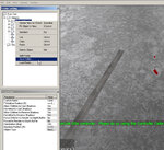
The focus on this thread is to discuss the tips and techniques used to create new 3D fields and modify existing fields with your own custom touches.

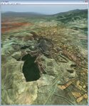
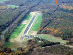
One of my favorites right now is the Painted Canyon in RF Add-On Volume 4. I have put runways on the sides of hills, tops of mountains etc. Then the challenge is to land and takeoff the SuperCub with Tundra tires on these. It really sharpens your skills.

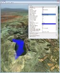
Last night I was trying to do a splash and dash on Alpine lake with the SuperCub. Can't quite get the technique right - so the Cub crashes and sinks to the bottom of the lake. What is so amazing is that if you are in Chase Plane view - you actually can watch the airplane and wings slowly sink to the abyss below.

How do they do that ????? Maybe someone will share that with us at some point down the line.

Now I am a total newbie and novice at this so I will be the one with the most questions. Please jump in and share your quetions as well as tips and techniques.

Anyway, Welcome Aboard!
 
My Initial Attempt - 3D Airport - Skyview

I have a new field partially built but need to learn how to add a hill to a runway.

The other problem I figure out is why trees don't show up. In the Environment > Edit mode I have trees lining the road. When I choose File > Exit To Simulatorthe trees are not there. In the View>Scenery I have selected All.

How do I make it so if I run into a building or a fence that it causes damage to the airplane or heli?

What settings/specifications makes Painted Canyon a sorta island in the sky (you can literaly fly out of the simulation into nothingness) and Flight School endless - you can literally fly any direction for hours and RF will keep generating scenary?

If I knew how - I would gladly upload Skyview Airpark so you could see what I've done and where I want to go with this
 
Pieces of the Puzzle

In the sister thread Designing Airports - Tips and Tricks, 12oclockhigh wrote in post # 2 about some of the pieces one uses in building airports.

Why build folders?


Primitives (Cube, Cylinder, etc.)
- What are primitives?
- How are they used?

Buffers
- What are Buffers?

Where can I find out what other components can be used to build a 3D airport?
 
Controlling the size of objects - like runways

What is the magic switch that allows you to draw something to actual dimensions? When I insert a runway and set the length - RF automatically sets the width.

Example: http://www.airnav.com/airport/7W4

The Bumpass Airport (7W4) runway at Lake Anna in VA is 2,558' long by 50' wide. Put 2,558' into the runway length parameter and RF makes the width 366' - wide enough to land the space shuttle.

How do I make RF accept manual input of width and length?
 

Attachments

  • 7W4 - Bumpass at Lake Anna.jpg
    7W4 - Bumpass at Lake Anna.jpg
    17.2 KB · Views: 21
12oclockhigh said:
There is no magic switch... you have to use multiples and choose the one measurement you want to hold... one or the other and it is sized. So choose your runway width and put multiple pieces end to end..
So there is a magic approach ..... not a single runway - but a number of segments patched together to get the size you are looking for. Brilliant! Thanks for the tip

12oclockhigh said:
This is the same gripe/problem/expectation I have of the primitives... it would be nice if the primitives were directly sizeable. So you have to work around the limitation. It is more understandable with the graphical pieces as the graphics would be distorted.
OK, Severe case of the DS here - what is a primitive? What do they do? How do you use them?

Thanks for stopping by :)
 
Keep in mind that this is a RC sim. Our planes don't weight tons. Try a runway around six hundred feet with your largest fastest bird to get a feel for what you might need. Adjust accordingly.
 
Fun2av8RC said:
Why build folders?

You can put all of the AP objects or just some of them in a folder and move them to another area of the same map or a different AP altogether and keep all of the objects in the same relative position (hopefully) see screeny
Fun2av8RC said:
Primitives (Cube, Cylinder, etc.)
- What are primitives?
- How are they used?

Buffers
- What are Buffers?
A Depth Buffer is a primitive
see post #2
https://forums.realflight.com/showthread.php?p=218256#post218256

Fun2av8RC said:
Where can I find out what other components can be used to build a 3D airport?

You can get custom objects here or request them in this threads sister thread https://forums.realflight.com/showthread.php?p=171409#post171409
you can also search the APs at the Swap page that may contain other custom objects (they are listed)
Once you DL and import the AP
those objects will be in the AP editors Object pallet under custom Objects for use in any AP
Note:
Some objects are only available if you own /have installed the Expansion Pack that they came from or if you have all 5 free Add-ons installed
 

Attachments

  • ScreenShot824.jpg
    ScreenShot824.jpg
    355.8 KB · Views: 32
Last edited:
Another important use for "Folders" in the editor, is that they permit you to import or export an entire airport hiearchy, or move an existing one to a new location INTACT.

You can also skillfully "rip off" other airport's.

e.g. I started the fenced off garden area in "Magnanimous John's" airport by using the walkway of the Castle AP. I exported this area as a single "folder" and imported and placed it to my own work. Then I added all of the fencing, trimming, etc.
 
Adding a Lake to your Scenery

Maj. Numbskully - I extracted the following from Your Post #2

You can not make hills or valleys in RF (I/we wish)
.all you can do is search around a field that is based in the "Sierra Nevada " map for something that might suit your needs ...its several hundred square miles of varying terrain so you may find something

OK, so I will stop trying to figure out how to do a hill since it can't be done. Thanks. Just curious - do you know where in the world the RF base map is from or is just a fictious geographical generation?


You CAN raise the water level to create Lakes and Islands but be forewarned this is a global setting and effects the WHOLE map...think of it as increasing or decreasing the worlds Sea level So if you have a Spawn point some where else in the map below the new water level.......it'll now be under water ! :eek:..mmmm Simulated Global Warming :p[/QUOTE]

So building a lake next to your new runway can't be done. OK, see the attached file. There is a dark green patch that looks like it should be a lake. Can I make this a lake with water that has depth and visibility?

In the properties for the base map, there are parameters that enable water, render water, Water Surface Altitude, and water visibility. How can I change the values for the green patch to make it a lake? I'don't want to just color it blue - I want to be able to land float planes on it, sail boats on it, etc.
 

Attachments

  • Landscape for new airport.jpg
    Landscape for new airport.jpg
    351.5 KB · Views: 27
Last edited:
But it is a hole

Apparently the green patch has depth to it. See attached. I found that by adjusting the Water Surface Altitude to 3300.00' - I can put water in the hole.

Now, how do I control the shape of the water so it conforms to the shape of the green patch?
 

Attachments

  • Controlling shape of a lake.jpg
    Controlling shape of a lake.jpg
    354 KB · Views: 32
Water there - now Airplane won't sink

Seems RF is just very capable of figuring out what you want and doing it for you. Once I saved the changes and reloaded the environment - the water conformed to the shore lines and I got waves. Pretty nifty. Figured out a few other tricks. Will post the results later tonight.
 

Attachments

  • Airplane won't sink into water.jpg
    Airplane won't sink into water.jpg
    349.3 KB · Views: 33
Fun2av8RC said:
Seems RF is just very capable of figuring out what you want and doing it for you. Once I saved the changes and reloaded the environment - the water conformed to the shore lines and I got waves. Pretty nifty. Figured out a few other tricks. Will post the results later tonight.

If you did, it was by a fortuitous accident.

The green patch was likely a farm or purposely lowered REAL terrain, when the original terrain scan was done for the mesh ( in Spain ).

So by raising the water level to just the right height, you got the water to conform to the MESH not the photo image, but the latter corresponds to the original scanned mesh.

There are many areas where this happens if the mesh accuracy is correct.
 
Yes You Can Make a Green Patch A Lake ...

In Post #11, Maj. Numbskully wrote that You CAN raise the water level to create Lakes and Islands but be forewarned this is a global setting and effects the WHOLE map...think of it as increasing or decreasing the worlds Sea level So if you have a Spawn point some where else in the map below the new water level.......it'll now be under water ! ..mmmm Simulated Global Warming.

In the case of the green patch, I just continued to increase the Water Surface Altitude until my lake at sufficient depth. However, as pointed out above, any terrain that was at or below the field elevation of the green patch became submerged. For my purposes, the setting gave me a lake with sufficient surrounding land to build a little airport with a hard surface runway. However, once airborne and flying around in simulated FPV mode (nose cam) I gotta pretty good idea of how Moses saw the word from the Arc. lots and lots of water.

I have since abandoned that site and am searching for a new location that better suites my needs.

I wish RF folks would fix this feature and give us a little more flexibility to create lakes were we want them and also the ability to create hills.
 
Fun2av8RC said:
I wish RF folks would fix this feature and give us a little more flexibility to create lakes were we want them and also the ability to create hills.

Ibid... along with included Terrain and 3D aircraft editors.... we can dream!
 
Back
Top