You are using an out of date browser. It may not display this or other websites correctly.
You should upgrade or use an alternative browser.
You should upgrade or use an alternative browser.
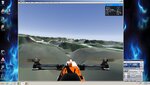
airport/sat image
- Thread starter RCjoe
- Start date
opjose
Well-known member
You could create a 3D Studio "object" using terrain data and import that object into Realflight as the "ground" for your new airport.
Most of this is beyond the scope of these forums....
e.g.
Using 3D Studio
Importing GIS data into 3D Studio
Creating a 3D Object from GIS data
etc., etc., etc.
---
Satellite images are unsuitable for airports as they are merely 2 dimensional flat representations.
The big reason for going through the effort is to accurately reflect elevation changes, which you can not do with 2D images alone.
Last edited:
12oclockhigh
Banned
In my 7 years using Real Flight, I have never seen this done. Good Luck, show us something.
csgill75
Well-known member
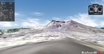
Mwilson914 has a terrain for Mt. St. Helens. It is a 3d object though but it works.
https://forums.realflight.com/index.php?resources/14184
https://forums.realflight.com/index.php?resources/14184
Attachments
Last edited:
12oclockhigh
Banned
Never became once... I have never seen this Mt. St. Helens field before... only 4 years old... pretty cool.